Tree Reports for Planning, Development and Construction – BS5837:2012
What is a BS5837 Tree Report?
Our consultants can provide BS5837:2012 Tree Surveys in accordance with British Standard BS5837:2012 Trees in relation to design, demolition and construction – Recommendations.
Local authorities are now placing a much greater emphasis on the importance of trees, hedges and woodlands within the planning process and will require relevant information to support a planning application when trees, hedges or woodlands are identified within, or near to, a development site.
If you are intending to build within close proximity of trees on your development site, including trees on neighbouring properties, the local authority will now expect a professional tree survey in accordance with BS5837:2012 to be carried out and this should form an essential part of a successful planning application. It is likely that your planning application will not be validated without one. The process is typically completed as explained below:

Why is it important to protect the trees on development sites?
Trees bring so many benefits – healthy established trees can provide amenity value, and provide habitats for the thousands of wildlife species that rely on the trees for food and shelter, along with providing environmental, social and economic benefits. One of the biggest threats to our trees in the UK can be from construction development. This threat can be from above ground threats which are easier to note but also below ground which are potentially more devastating to a tree and damage may not be apparent until several years after the development has been completed. Examples are excavations within a tree’s rooting area, soil compaction damage sustained from heavy construction vehicles, or the positioning of buildings too close to a retained tree’s branches or roots. Retaining good quality trees and mitigating tree loss in order to prevent the potentially negative impacts of construction is crucial. Trees may also be protected by statutory laws such as tree preservation orders so their consideration in your development project is vital in order to prevent a potential prosecution from the local authority and incurring large fines if it is later proven that your development has caused damage to these trees. Trees growing on land adjacent to your development might have roots which extend into your development area and so also need to be fully considered.
The Pre-application Stage
In the early stages of any building project, the parties involved must consider the potential impact of their proposals on the trees on or adjacent to the site. This can be achieved by carrying out a tree survey at the site before any development plans are drawn up. If the plans have already been drawn up as occasionally happens, the tree survey can still be undertaken but may determine that changes to the plans will be required to mitigate impact to particular trees on site in order to make planning consent for your development more likely. For example, your existing plans may encroach too far into the root protection area of a retained tree, changes may need to be made to facilitate a different construction method that is more sympathetic to tree roots such as an above ground alternative such as a 3D cellular confinement system such as cellweb, or perhaps material storage areas, landscape plans or site access plans need to be amended to avoid damaging any trees on site. We can also provide suggestions to mitigate tree loss where it is unavoidable. For this reason, we always advise contacting us at the pre-application stage after a topographical survey has been carried out so that we can work alongside your architect and provide advice before your final development site plans are drawn up and submitted.
First Steps – Topograhical Survey
To begin the process, we will ideally require a topographical site plan in a DWG file that includes spot levels and positions of all trees and hedges on the site with a stem diameter of 75mm or greater. The plan will also need to plot trees with an estimated stem diameter of 75mm or more that overhang the site or are located beyond the site boundaries distance of up to 12 times their estimated stem diameter. In the case of woodlands or substantial tree groups, only individual trees with stem diameters greater than 150mm usually need be plotted.
A topographical survey is an exercise undertaken by a land surveyor and is a detailed, accurate plan of a specific site or area of land. It will identify all relevant existing, natural and artificial features such as building, site boundaries, trees, utilities covers, site levels and many other attributes. The gathered data is usually presented on a CAD drawing.
Where a topographical survey is not available it may be possible for us to obtain a plan of the trees on site using National Tree Map data or other methods. Please enquire for further details.


Next Steps – Arboricultural Site Appraisal Report including Tree Survey Plan, and Arboricultural Impacts Assessment including Tree Retention Plan
Upon receipt of your topographical survey, we will arrange a site visit to carry out the initial site survey for the Arboricultural Site Appraisal Report. This report includes an assessment of the site and its surroundings, the tree population and a tree quality categorisation for each tree, a root protection area calculation, details of any above and below ground tree constraints, details concerning any ground level changes, and details on statutory protection and guidance. A tree survey schedule will be provided for all trees that need to be considered on site. Based on your supplied topographical survey plan, we will also provide a Tree Survey Plan drawing at this stage to indicate where the trees are located and their root protection areas. All reports and drawings are supplied electronically in PDF and DWG format for each of sharing within the project team. All drawings are produced in-house using AutoCAD. This drawing will be supplied to your architect and incorporated into their design so that the trees can be fully considered or overlaid onto their existing plans so that it can be identified where any conflict lies which can then be mitigated.
Upon receipt of the final proposed development plan from your architect, we can complete an Arboricultural Impacts Assessment which is a written report determining the effect of a planned development on the existing trees on site and suggesting mitigation measures such as new trees to replace any recommended for removal. It includes a Tree Retention Plan which will highlight which trees are to be removed and identify trees which may require remedial works.


Additional Steps – Arboricultural Method Statements, Tree Protection Plans and Site Supervision and Monitoring
If your planning application is successful, the local authority may occasionally decide to attach a planning condition to the consent that an Arboricultural Method Statement is produced. This would usually be where tree pruning is required or construction activity will take place within a root protection area of a retained tree. We usually stipulate in our Arboricultural Impacts Assessment that this is made a planning condition so that the costs for this are not incurred at the application stage in case your application is not successful.
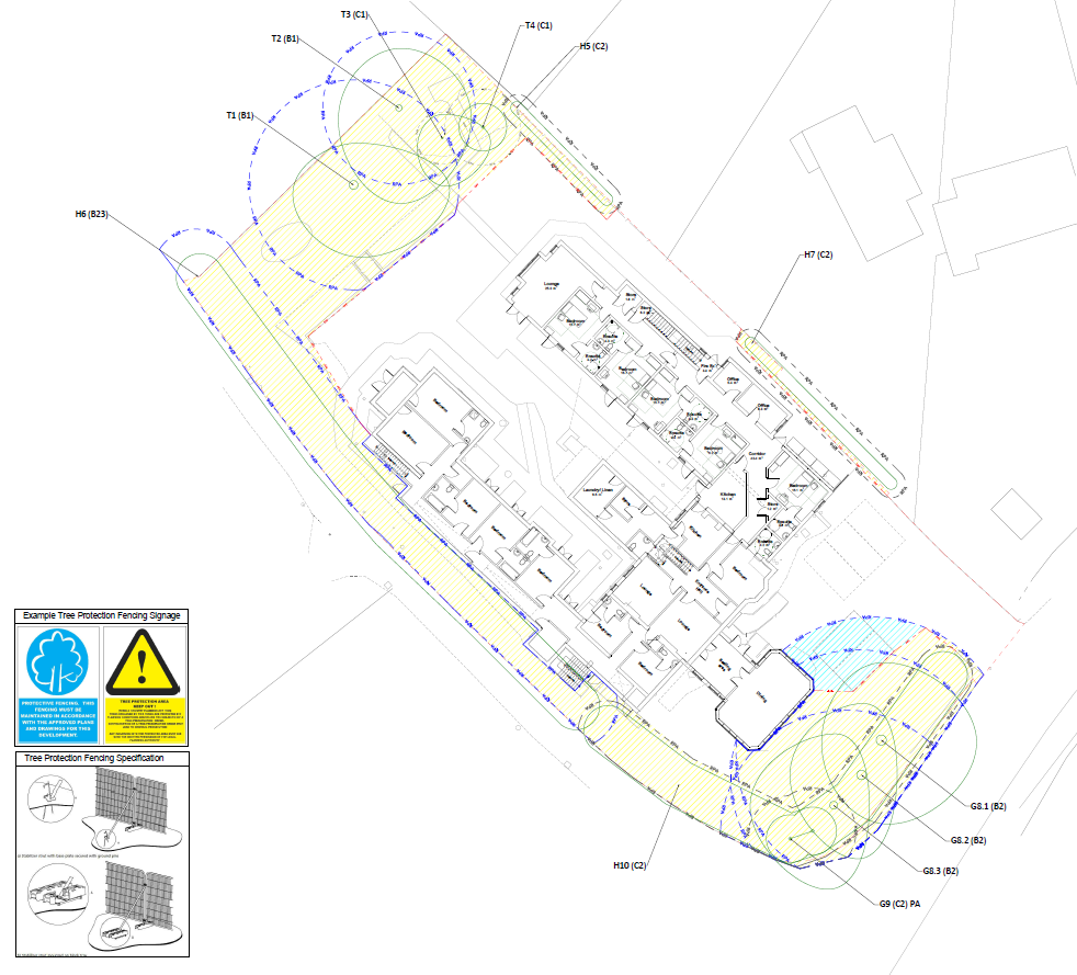
A Tree Protection Plan is drawn up to ensure that that trees are fully protected, before and during any construction activity that takes place on site and tree protection measures such as temporary tree protection fencing barriers and ground protection to prevent soil compaction will be identified on the plan. It will also highlight which trees are to be removed and identify trees which may require remedial works.
Additionally, the local authority may also stipulate that Arboricultural site supervision and monitoring must be undertaken at key stages of the build process to ensure that the principal contractors are adhering to the build process as detailed in the Arboricultural Method Statement.

Please contact us to discuss your development project in further detail and we will be able to send a fee proposal for our services.